Monday, January 15, 2018

Sheepview 360-How Camera Laden Sheep Put the Faroe Islands on the Map

Literally meaning 'Island of the Sheep', the Faroe Islands are the stunning Nordic paradise you've never heard of. Nominally part of the Kingdom of Denmark, the Faroe Islands are located between Iceland and Norway. They're a small nation with less than 50,000 people, and there's almost twice as many sheep as people. The Faroes are a lovely, tucked away, almost completely unknown chain of islands in the North Atlantic.

Image result for Durita Dahl Andreassen
Ms. Andreassen with her sheep.
Google, on the other hand, is everywhere. Google has pictures of your house, your street, your dog (possibly). They make the operating system for your cellphones¹, the operating system for your laptops, they provide the program for your calendar, your mapping technology, even for a simple internet search. Hell, I'm using Google software to write and publish this post. Google is everywhere; you cannot escape Google.

Unless you lived on the Faroe Islands, that is. Until late 2017 Google had never taken pictures of the island, possessing only sattelite images of the landmass from above. Almost everywhere else on earth has Google Streetview--a program that allows users to see different cities and countries at ground level-- except the Faroe Islands. In an effort to boost tourism, the Faroe Island Tourism Board decided that they wanted Google to bring streetview to their islands.

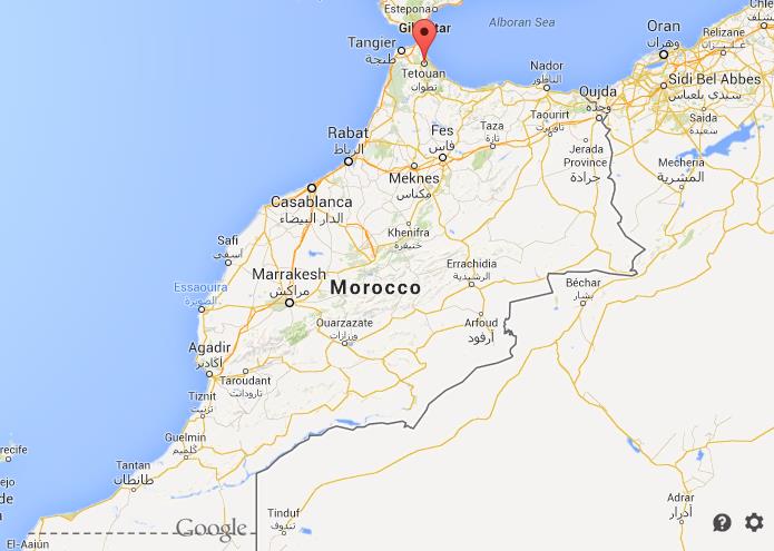
Given that the Faroe Islands have been left off maps before, this is entirely understandable. The Faroes are a tiny 'blink-and-you'll-miss-it' country in the middle of the Atlantic. They aren't as popular as neighboring Iceland, but a large portion of their economy relies on tourism. Having Street View would help make the Faroes a more appealing place for tourists, and so the Faroe Islands decided to get Google's attention.

Image result for faroe islands
The Faroe Islands
Now, admittedly, tiny rocks in the middle of the Atlantic aren't usually Google's top priority.² It isn't cheap to do the photography for Street View, and the roads in the Faroe Islands are not for the faint of heart, so Faroe Tourism Board member, Durita Dahl Andreassen, decided that she would make use of the Island's resources. Enlisting (or pressganging, depending on the situation) the help of the island's epynomous sheep, she fitted several sheep with harnesses that could hold a 360 degree camera, and set the sheep off into the wild.

Now, ancient laws of the Faroe Islands dictate that sheep are allowed to go wherever the hell they want on the islands. This, combined with the fact that they can leave roads and get to normally inaccessible places made them ideal camera operators. The footage they shot was sent directly to Andreassen's phone, and she uploaded it to Google Maps. She dubbed the project 'Sheepview 360', and with the help of the Faroe Islands Tourism Board, created a website and released several YouTube videos to get Google's attention. They encouraged locals to use the hashtag #visitfaroeislands and #wewantstreetview, and before long they caught Google's attention.

While a clever idea, sheep aren't exactly the most reliable of cinematographers. They spend a lot of time in the same place, and they don't quite understand the need for care with fragile technology. However, Sheepview hit its intended mark. Hotel reservations are up 10% from last year, and there has been a marked increase in tourism.

If you're interested in watching the Sheepview videos, you can find them all here.


¹Iphone owning readers, you've been acknowledged, now hush.
²Tristan da Cunha STILL doesn't have Street View, and I am extremely salty about this. Sure, it's the most remote island in the world, but that's no excuse. Get on it Google.


Sources
Sheep with a 360 View
How Sheep With Cameras Got Some Tiny Islands on Google Street View

Wednesday, January 10, 2018

Punt, the Mythical Land of Where?

Though there is archaeological evidence that people have been to Punt, there is no actual archaeological evidence of Punt itself. No structures, tombs, or definitively 'Puntite' artifacts have been found. Everything we know about the Land of Punt comes from the Ancient Egyptians who traded with them.

Image result for land of punt
A Puntite chieftain and his wife.
Most of what we know about the land of Punt comes from the mortuary temple of the Egyptian pharaoh, Hatsheput. Hatsheput, who is noted for having led Egypt into an era of wealth and prosperity, launched the largest recorded expedition into Punt. She was so proud of this expedition that she had it recorded on the walls of the temple dedicated to her. The brightly colored carvings depict a lush land, with beehive shaped houses set on stilts. It depicts Egyptians bringing back live trees, as well as animal skins and gold. The roots of the depicted trees can been seen around her temple.

Punt was very important to the Egyptians economically, and the two countries were close trade partners. As opposed to the deserts of Egypt, Punt was lush and brimming with life. They provided Egypt with incense trees, wood, and animal skins, while the Egyptians brought them jewelry, metal, and tools.

While Punt was certainly a wealthy land, trade wasn't the only reason the Egyptians were so intrigued about it. For the Egyptians, Punt was the land of their gods. Hathor, the goddess Hatsheput claimed as a mother, lived there, as did Ra. Many of the symbolic objects used in Egyptian religious practices came from Punt, and the Ancient Egyptians viewed Punt as their ancestral homeland.

Image result for land of punt
Egyptian soldiers on the expedition to Punt
The civilizations of Punt and Egypt flourished alongside each other for centuries, yet to this day the location of Punt has been 'lost'. While archaeologists have, and still are, plundering the sands of Egypt for answers about the past, archaeologists and scholars alike are still scratching their heads about Punt. As mentioned above, no structures or artifacts that are distinctively 'Puntite' in nature have been found, so no exact location can be pinned down, but thanks to Egyptian records, artwork, and writing, there are several working theories as to where Punt is.

The oldest (and least credible) theory is that Punt was located on the west coast of the Arabian Peninsula to the Northeast of Egypt. Put forward in 1850, this theory was based purely on the aromatic trees and gums that the Egyptians brought back from the land of Punt. Frankincense, one of the most recognizable trees brought from Punt, grows almost exclusively in the Southern Arabian Peninsula (modern Oman and Yemen), and around the Horn of Africa (modern Somalia, Djibouti, Eritrea, into Ethiopia).

Image result for land of punt
Puntite house surrounded by trees.
However, further reexamination of the reliefs on Hatsheput's temple disproved this theory. The reliefs depicted elephants, rhinoceroses, and giraffes--none of which are indigenous to Arabia. They are, however, indigenous to the Horn of Africa.

Coincidentally (or not!), Frankincense and myrrh trees are also indigenous to the horn. Additionally, the methods of transportation described by the Egyptians make sense for traveling to the Horn of Africa. The reliefs on Hatsheput's temple depict the Egyptians sailing in boats. The fish depicted below the boats can be positively identified as species which still live in the Red Sea. The Egyptians most likely sailed down the Red Sea, hugging the coast until they reached Punt. Additionally, they could have sailed down the Nile, dissembled their ships, and walked over land to Punt, returning the way they came or via the Red Sea.

From the Horn of Africa there are two major contenders for the location of the Land of Punt--the state of Puntland in Somalia, and a region in East Sudan/North Ethiopia.

Related image
Egyptian soldiers loading the boat for the expedition to
Punt. Note the fish under the boat.
The largest evidence in favor of Somalia is the linguistic and cultural similarities between current Somali society and Ancient Egyptian society. Somali shares several words with the same language spoken by the Ancient Egyptians, and historically they Somalis called their region 'Bunn', which the Egyptians could easily have translated as 'Pwenet', which has been translated to Punt. In addition, traditional Somali dances are very similar to the dances depicted in Ancient Egyptian reliefs.

In the favor of Sudan/Ethiopia is descriptions from the Greek traders who made it there as well. Greek writing about expeditions to Punt include descriptions of what is most likely today's Lake Tana, as well as Lake Awsa and the Island of Dak. There are several other descriptions that match geographical features in Ethiopia and Sudan. Add in the fact that there are large regions of incense tree (frankincense and myrrh) producing lands in these regions, it seems just as likely that Punt could be in the region that is now East Sudan and North Ethiopia.

Unfortunately, despite strong evidence for many of these places, there is no definitive archaeological proof of any of them, and it seems likely that the same scholarly argument started in the 1800s will continue for a while more. Personally, I'm dying of curiosity, so if you're an archaeologist, please move finding Punt to the top of your 'to-do' list.


Sources
Punt
Somalia: the Ancient Lost Kingdom of Punt is Finally Found
Will We Ever Discover the Elusive Land of Punt?
Where is Punt?
Punt, Historical Region, Africa

Sunday, January 7, 2018

Damn, Girl-Sayyida al-Hurra

Though she's been largely forgotten to history, Sayyida al-Hurra--known as the 'Pirate Queen of Morocco'--ruled the entire west Mediterranean, as well as a sizable Moroccan city state in the 1500s. She harried the Spanish and Portuguese, invaded modern Gibraltar, and forced the smitten King of Morocco to marry her on her own terms. She was a remarkable woman, and we don't even know her name.

Image result for Sayyida al hurra
Artists rendering of Sayida al-Hurra. There are no
surviving portraits that are definitively of her.
'Sayyida al-Hurra' is a title, not a name. It means 'noble lady who is free'. The title al-Hurra was given to women who ruled a kingdom (or queendom!) in their own right. For Sayyida, that kingdom was the coastal city state of Tétouan, where she ruled for a quarter of a century.

Sayyida was born in the then Muslim held Andalusia region of Spain. Her father, Moulay Ali ibn Rashid, was a tribal chief, and a wealthy man of Moroccan descent. However, they, along with many other Muslims, were forced out of Spain during the Reconquista. They fled south to Morocco, and with other refugee families, established the city of Chefchaouen. Sayyida's father was declared king, and as his daughter, Sayyida was given a good education, learning at least two languages and gaining an understanding of international diplomacy.

When she was sixteen Sayyida was married to the ruler of Tétouan. Though she was very young, her husband relied on her for political advice and support¹, and she soon became his chief wife. Tétouan had important trading connections with the Portuguese city of Ceuta, and Sayyida's language skills as well as her grasp of economics and diplomacy was an enormous asset to her husband.

Sayyida's husband died sometime between 1515 and 1519, and Sayyida was made the queen of Tétouan. As we've discussed before, it wasn't too unusual for a woman to be a regent to a young heir, or be a regent and then refuse to relinquish power, but in Sayyida's case she was named queen in her own right, and not a regent. According to Islamic historians, she was the last such queen to hold a city or region in her own right.²

Image result for tetouan morocco
Modern Tétouan
At this time, thousands of refugees were still streaming in from Andalusia, and the Spanish and Portuguese were starting to sniff around Morocco. They were raiding, colonizing, and enslaving everyone and everywhere they could, and Sayyida, justifiably, had a massive beef with the Iberian's, so she decided to team up with the notorious pirate--Barbarossa.

With the help of Barbarossa, Sayyida assembled a fleet, and set about dominating the west Mediterranean. With Barbarossa controlling the east and Sayyida the west the pair gave the Spanish and Portuguese hell, invading and raiding all over the Iberian peninsula, seizing money, goods, and prisoners.

All of this raiding made Sayyida ridiculously wealthy, and extremely popular. In 1541 she caught the eye of Sultan Ahmed al-Wattasi, and he proposed. Sayyida accepted his proposal, but refused to leave her city, and marry in Fez. The fact that the Sultan acceded to her demand and married her in Tétouan is a testament to her strong will and the respect that Moroccans had for her.

However, Sayyida's power was waning. The Portuguese had had enough of her raiding, and the city of Ceuta cut off trade ties, putting many of Sayyida's people out of work. That combined with a coup led by her son-in-law led to Sayyida fleeing Tétouan in 1542. She returned to the city of her childhood--Chefchaouen--where she lived for another twenty years.

Image result for Tétouan map
Tétouan, Morocco
Today Sayyida is known as a great pirate queen, but there's more to her than that. She robbed and pillaged Spanish and Portuguese ships, but she also conducted refugees from Andalusia safely to Morocco. She used her network of pirates to protect her people from Iberian incursions into Morocco. The Moroccan's had no formal navy at the time, so Sayyida used her pirates to protect Morocco's coast This raises the question--was Sayyida a pirate or a protector?


¹This sort of thing was not uncommon. Andalusian Muslims had a strong tradition of women in leadership positions, and as such women's opinions and advice were respected and followed. This, however, does not nullify the fact that Sayyida was a remarkable leader.
²'al-Hurra' denotes a woman who is queen of a region in her own right.


Sources
Sayyida al Hurra
Lady Pirates: Queen of the Barbary Corsairs
Sayyida al-Hurra, Islamic Pirate Queen
Malika VI: Sayyida al-Hurra

Wednesday, January 3, 2018

Baghdad House of Wisdom

When Rome fell Europe was thrust into the so named 'Dark Ages'. However, while the Europeans were scrabbling around, getting the plague and fighting each other over buckets, West Asia was was enjoying a golden age.

Image result for baghdad house of wisdom
Scholars of the House of Wisdom
This golden age spread across all the Islamic nations, from India to the Arabs living in what is now Andalusia, Spain, and at the center of it all was Baghdad, the wealthy cultural capital of the Islamic world.  It was a magnificent city, but the most magnificent part of it was it's House of Wisdom--a large library which also served as a sort of university.


The House of Wisdom was founded in the early 800s by Caliph al-Ma'mun, a highly educated man with an intense interest in science, mathematics, and medicine. There had been many large private libraries prior to this, but al-Ma'mun took things one step further. He had his private library collected under one roof, and made available to scholars--male and female, Muslim and non-Muslim--from around the world. Successive Caliphs followed in this tradition by acquiring more and more books, and expanding on the House. At the time of its destruction, the House of Wisdom not only had an enormous library, but a hospital and an observatory as well.

The library at the House of Knowledge was enormous, and was made even more enormous by several large ticket purchases. During the reign of al-Ma'mun, the entire library of the Kingdom of Sicily was acquired. al-Ma'mun, a scholar himself, had heard of the great library in Sicily, and wrote to the Sicilian King, asking for its contents. The Sicilian library had several classical works about science and mathematics, and all Ma'mun was eager to get his hands on them. The Sicilian king consulted with his advisers, who told him that those books hadn't done the ancients any good, and the Sicilian king gave al-Ma'mun his library, a library which, according to legend, took more than 400 camels to transport.
Image result for medieval baghdad map
Map of Baghdad during its Golden Age
The translation of texts from Greek, Latin, and Sanskrit into Arabic was highly encouraged. So much encouraged that the Caliph al-Ma'mun offered to pay scholars the weight of a completely translated book in gold. Because of this, scholars translated the works of Aristotle, Hippocrates, and Plato into Arabic, preserving these works for future scholars, and giving scholars to opportunity to comment and study them.

Another notable translation that came from the House of Wisdom, was the translation of several Indian texts about mathematics. This was particularly important because, as you might know, it was Indian mathematicians who invented the concept of zero. In addition to zero, scholars also discovered that Indians used ten separate symbols, or combinations of those symbols, to represent numbers, not letters of the alphabet like the Romans and Arabs up to that point had. This led to experimentation on the part of Arab mathematician, and ultimately resulted in the Arabic Numeral system--the system we use today.

Image result for astrolabe
An astrolabe
Completely reinventing mathematics wasn't the only major scientific advancement made at the House of Wisdom. The astrolabe--a tool used for navigating the ocean--was invented there, as well as the discipline of chemistry. Additionally, the world's first general hospital--the forerunner to today's modern hospital--was built in Baghdad. There scholars from around the world studied medicine, making advancements in surgery, epidemiology, and physiology.

Much like the Library of Alexandria, the House of Wisdom met an unfortunate and bloody end. In 1258 the Mongols invaded Iraq. They sacked Baghdad, putting the Caliph and his family to the sword. In an act that makes any book loving person furious, they dumped the books from the House of Wisdom into the Tigris river, letting thousands of years of precious knowledge be washed away. Then, to make things even worse, they killed all the scholars. It is said that for years after this the muddy brown waters of the Tigris ran black from ink and red from blood.


Sources
Baghdad: Libraries and House of Wisdom
The Abbasids' House of Wisdom in Baghdad
The House of Wisdom: Baghdad's Intellectual Powerhouse
The House of Wisdom, One of the Greatest Libraries in History
House of Wisdom